TOPOGRAPHIC LEVELING
Topographic leveling in surveying is a process of measuring the elevations or altitudes of points on the Earth’s surface. Elevation or altitude being understood as the vertical distance measured from a reference surface to the point considered.
The vertical distance is measured along a vertical line that follows the direction of gravity or the direction of the plumb bob.
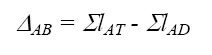
The difference in level between two points (∆AB) is the vertical distance between the surfaces that pass through these points. The unevenness can also be defined as the difference in elevation or elevation between the two points.
Elevation: ∆AB = QA – QB
There are different types of leveling. Trigonometric leveling uses vertical angles to determine the unevenness between points. Tachymetric leveling relies on optical distance measurement for the altimetric location of points on the earth’s surface.
If we call lA, l´1, and l´2 read back (lAT) and l1, l2, and lB read ahead (lAD), we have:
The following table summarizes the calculation process for compound leveling:
In the table, column 1 identifies the station points, column 2 the points of location of the staff, columns 3 and 4 the back-and-forth readings at the shift points; in column 5 the partial slopes ∆p = LAT – LAD, and in column 6 the elevations of the remaining points are calculated from the elevation of the known point (A) and the partial slopes.
As a control, the sum of the back readings (column 3) minus the sum of the forward readings (column 4) must be equal to the sum of the partial slopes (column 5)
Therefore, the difference in level between point A and point B is equal to:
∆AB = 9.508 – 10.691 = – 1.183, the negative sign indicates that point A is higher than point B.
Hoping that the article has been of interest to you or a particular topic that you would like us to publish, we await your comments, questions, or suggestions. Thanks!!!
Bibliographic reference:
LEVELING
Leveling in surveying is a process of measuring the elevations or altitudes of points on the Earth’s surface. Elevation or altitude being understood as the vertical distance measured from a reference surface to the point considered.
The vertical distance is measured along a vertical line that follows the direction of gravity or the direction of the plumb bob.
The unevenness between two points (∆AB) is the vertical distance between the surfaces that pass through these points. The unevenness can also be defined as the difference in elevation or elevation between the two points.
Elevation: ∆AB = QA – QB
There are different types of leveling. Trigonometric leveling uses vertical angles to determine the unevenness between points. Tachymetric leveling relies on optical distance measurement for the altimetric location of points on the earth’s surface.
Geometric leveling or differential leveling, which is the most commonly used, is a topographic procedure that allows us to determine the unevenness between two points by using an optical level and the vertical or stadial sight.
Geometric leveling measures the difference in level between two points from the horizontal sight launched from the optical level towards the staffs placed at said points.
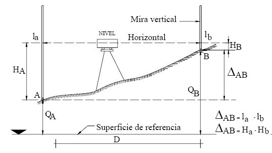
In fig. A simple geometric leveling can be observed, the difference in level between the two points can be estimated with a single station, that is, without moving the optical level from its place, through a height difference, ∆AB = La – Lb = Ha – Hb
But when the points are separated at a distance greater than the limit of the topographic leveling field, or the scope of the line of sight, the placement of intermediate stations is necessary and it is said to be a compound leveling, as can be seen in the following figure. But when the points are separated at a distance greater than the limit of the topographic field,
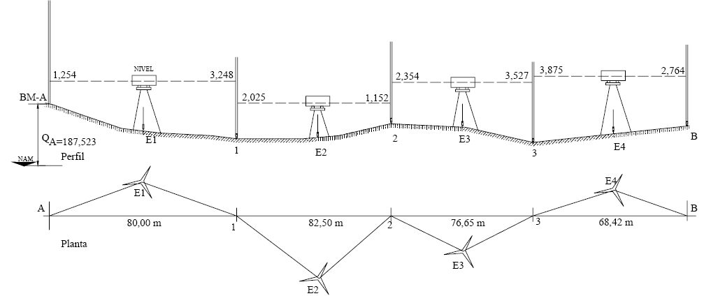
Compound leveling consists of the successive application of simple leveling. In the figure, points 1, 2, and 3 represent the switching points (PC). Point A is a Measurement Base (BM) or known elevation point. E1, E2, E3… represent station points located at points equidistant from the staffs and the values (l) represent the readings on the staff.
The unevenness between A and B is obtained by the sum of the partial unevenness.
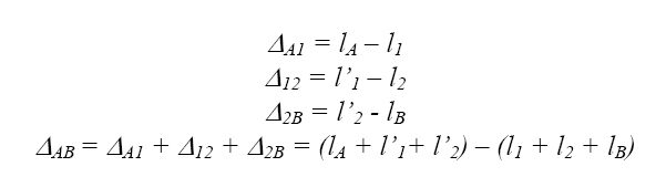
If we call lA, l´1, and l´2 read back (lAT) and l1, l2, and lB read ahead (lAD), we have:
The following table summarizes the calculation process for compound leveling:
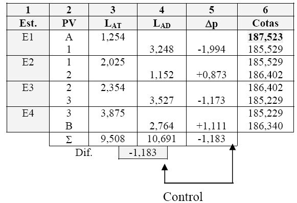
In the table, column 1 identifies the station points, column 2 the points of location of the staff, columns 3 and 4 the back-and-forth readings at the shift points; in column 5 the partial slopes ∆p = LAT – LAD, and in column 6 the elevations of the remaining points are calculated from the elevation of the known point (A) and the partial slopes.
As a control, the sum of the back readings (column 3) minus the sum of the forward readings (column 4) must be equal to the sum of the partial slopes (column 5)
Therefore, the difference in level between point A and point B is equal to:
∆AB = 9.508 – 10.691 = – 1.183, the negative sign indicates that point A is higher than point B.
Geometric leveling or differential leveling, which is the most commonly used, is a topographic procedure that allows us to determine the unevenness between two points by using an optical level and the vertical or stadial sight.
Geometric leveling measures the difference in level between two points from the horizontal sight launched from the optical level towards the staffs placed at said points.
A simple geometric leveling can be observed, the difference in level between the two points can be estimated with a single station, that is, without moving the optical level from its place, through a height difference, ∆AB = La – Lb = Ha – Hb
But when the points are separated at a distance greater than the limit of the topographic field, or the scope of the line of sight, the placement of intermediate stations is necessary and it is said to be a compound leveling, as can be seen in the following figure.
Points 1, 2, and 3 represent the switching points (PC). Point A is a Measurement Base (BM) or known elevation point. E1, E2, E3… represent station points located at points equidistant from the staffs and the values (l) represent the readings on the staff.
In the figure, points 1, 2, and 3 represent the switching points (PC). Point A is a Measurement Base (BM) or known elevation point. E1, E2, E3… represent station points located at points equidistant from the staffs and the values (l) represent the readings on the staff.
Compound leveling consists of the successive application of simple leveling. In the figure, points 1, 2, and 3 represent the switching points (PC). Point A is a Measurement Base (BM) or known elevation point. E1, E2, E3… represent station points located at points equidistant from the staffs and the values (l) represent the readings on the staff leveling.


