LAND LEVELING BY THREE-DIMENSIONAL REGRESSION Method of leveling is a branch of surveying, the object of which is to establish or verify or measure the height of specified points.
Classification of leveling methods
The altimetry work, or land leveling, is intended to determine the height of its points on a level surface, which is taken as a comparison surface and is called heights. The elevation of a point referred to as sea level will be called altitude. All work must start from a point of origin of known altitude of arbitrary height.
In leveling, unlike the flat representation of the topography, we must be very careful with errors, since in altimetry the level surfaces must be considered spherical. We must bear in mind the errors of sphericity and refraction and that they are contained within the required tolerances.
Topography
Almost all the Topography treatises offer a way to keep a leveling book and, consequently, the way to correctly carry out the different operations in the field. These procedures are demanding and require the operator to check every step; however, they have the disadvantage of complicating the calculations, for which we will indicate here a much more expeditious procedure, with which a moderately practical operator will quickly carry out all the checks, saving time and work.
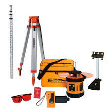
Of course, the leveling is carried out using a suitable surveying instrument and a scope. For now, let’s dispense with the kind of instrument used, be it a level with a telescope or with a collimator, laser beam, GPS, etc .; and the same about the sight, which can be speaking, tablet, laser receiver, …
You start by placing the level, that is, putting it in the station, on a point from where you can read the sight placed at the point of origin or at the other points to be leveled. The staff is then placed vertically over the starting point. The level, which moves only in the horizontal or azimuthal plane, is directed to the staff, and reading is made. This reading is added to the number, known in advance, which expresses the tachymeter height of the starting point. The resulting number gives the elevation of the plane, which we call the level plane, which is the horizontal plane (parallel to the XOY plane in a three-dimensional representation in rectangular Cartesian coordinates) to which all the points that can be leveled without changing the level of its site; this plane passes through the optical axis of the level.
Dimensional
It is easily understood that it will then be enough to subtract all the readings made at the different points where the sight is placed, from the number that indicates the height of the level plane, to have all the heights or tachymetric heights sought. The simplicity of these calculations offers the advantage of allowing the operator to calculate the various points as the operation progresses so that if in the course of leveling he finds a known reference point, he can carry out the check immediately. which will save you from having to return to the field.
As in tachymetry, there are several altimetry methods. The one most used to obtain the unevenness between two points is the so-called “geometric or height leveling”, “trigonometric or slope leveling” which can also be used, and, finally, barometric leveling. Of all of them, the most important is geotechnical or height leveling and the most imprecise is barometric leveling, now practically in disuse.
The geometric or direct method of leveling (by heights)
Definition
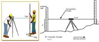
This is understood as the determination of the difference in level between two points using horizontal visuals towards sights or graduated rulers, which are located in a vertical position on the points to be leveled (Figure 2). It allows the direct determination of the heights of various points, by measuring vertical distances concerning a level surface, whose height is already known to us in advance. Leveling by heights can be simple or compound. It is “simple” when the points whose unevenness we intend to take are close together, and if, on the contrary, they are far away and it is necessary to take intermediate points, making changes to the season, it is a leveling “Compound”. The difference in level (Dh) existing between any two points 1 and 2 on the ground is immediately calculated by finding the difference between the readings of the staff on them, that is:
Dh = l1 – l2 (see Figure 2)
To carry out this type of leveling, optical devices called levels or equialmeters are used that direct horizontal visuals (with lysimeters, on the other hand, a certain slope can be provided to the visual) and the precision of the measurements carried out will depend, fundamentally, on the characteristics of the instruments used. In fact, other surveying instruments equipped with an altimeter could also be used as a level, making the horizon height of the line of sight zero; but from the moment that the telescope has a rotation, this horizontality cannot be achieved with the precision that is achieved with a telescope level, in which it rests on support or is attached to it. The levels also make it possible to determine the distance and the horizontal or azimuth angles as they are provided with the corresponding limbus. This method is generally used on not very rugged terrain.
Equidistant station methods.
As we have previously indicated, apart from the method to be used in direct leveling, there are the following types: simple leveling, which considers an instrumental position, and which can be done by the method of the midpoint, by the extreme point, by reciprocal stations and by that of equidistant stations. And the compound levelings or altimetry itinerary, which consider more than one instrumental position for what they are but a repetition of simple levelings; include the midpoint, double station, and equidistant station methods.
The midpoint leveling method, in addition to being the most recommended, is the only one that eliminates systematic level errors, even those of faulty correction, sphericity, and refraction. It is done by placing the device at the same distance from each of the points to be leveled. On the contrary, the extreme point method is carried out by placing the sight on one of the points and the apparatus on the other, and it is of course advisable not to read distances greater than 100 meters.
Elements
The reciprocal station’s method brings new elements. Indeed, although the previous ones have the disadvantage of their lack of verification, this last method allows to park first in one of the points and take the other and, later, to do the same but to the contrary; This serves as an apparatus check and eliminates systematic level errors. Finally, there is the method of equidistant stations that also eliminates errors, although we do the work of readings twice.
Simple leveling
Simple longitudinal leveling:
Points are defined along a line, without the need for these points to pass through this line.
Simple radial leveling:
It is very similar to the previous one, but the difference with it is that the points, in this case, are distributed in an area and not in a straight line. Radial leveling, as its name suggests, takes place by centering the device and taking the points radially; It is highly recommended if we intend to raise a terrain altimetrically, taking the points that define it, also taking advantage to raise the area planimetrically.
Simple leveling composition
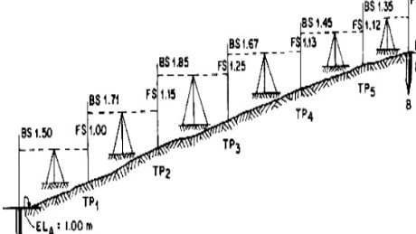
Within the compound leveling method, when the points whose unevenness is to be found are located at a great distance, a series of intermediate points have to be taken, obtaining the unevenness between every two consecutive ones. When traveling the route from one end to the other, we must use the midpoint method, of course closing the leveling and calculating the corresponding closing error. The error that we obtain, called “kilometer error or closing error”, is expressed in millimeters and should not be greater than 7 millimeters, as will be seen later.
In this section, two main types or modalities are distinguished:
Longitudinal compound leveling:
This leveling is made up of two or more instrumental positions, but the points are distributed along a straight line, or in other words, it would be a matter of joining two or more longitudinal levels.
Radial compound leveling:
This leveling modality, like the previous one, is made up of two or more instrumental positions, but with the difference that the points are distributed in an area; in other words, it would be like having two or more radial levels joined together.
Other types
Open and closed levels:
It should be noted that there are two types of leveling, regardless of the type to be used, which are both open leveling and closed leveling, specifying that open leveling will be when there is no verification; It consists of starting from a known elevation to later arrive at an unknown elevation point. On the contrary, a closed leveling is one in which the closure error can be verified, since it starts from a point with a known elevation and later, after following a specific topographic route, it will arrive at another known elevation, which can be treated even from the same starting point.
Method of Leveling by double instrumental position:
It consists of making two records per difference, since, for a series of points, two series of instrumental positions will be carried, one from the right and the other from the left, according to the direction of advance. All this in such a way that when both slopes are located within the tolerance ranges, the arithmetic average of them will be taken as unevenness; otherwise, the measurements of the dimensions will have to be taken again.
Leveling by double sights:
This leveling consists of using two sights; These sights are located at the same point, in such a way that one of them is placed inverted to the position of the other. Thus, once the reading of both staff has been made at the same point, the sum of both readings should be the length of the staff; otherwise, the measurement must be repeated.
Reciprocal levels:
This leveling is used when taking readings from inaccessible places, and the position of the level concerning the sights must be extreme since it is located very far from one and very close to the other. These extreme readings can be internal to the sights or externally to them, but always keeping a straight line.
Indirect method of leveling
Trigonometric leveling (by slopes)
Using this system, unevenness is determined by measuring vertical or zenith angles and the distances between the points to be leveled (Figure 3). It can be determined with a tape and a lysimeter or, with a theodolite, by basing its resolutions on a right triangle located in a vertical plane, so measurements of horizontal distances and vertical or zenith angles are taken. Once the corresponding operations have been carried out, the tachymetric height difference between both points A and B on the ground will be given by:
Dh = Dh1 + Dh2
This type of grading is mainly used on steep slopes. For this, optical devices are used to measure distances as well as horizontal and vertical angles. These instruments are called theodolites.
Barometric method of leveling.
The difference in level is determined, in this case, using a barometer or altimeter, since the difference in height between two points can be measured approximately according to their relative positions under the surface of the atmosphere, about weight. of the air or atmospheric pressure gravitating on them, which is determined by the barometer. The pressure at sea level is 761 mm. column of mercury. Every 100 m. high the atmospheric pressure varies from 0.7 to 1.0 cm. column of Hg.
In fact, this method is the most imprecise of all those exposed and is useful only for examinations, so we will simply limit ourselves to your appointment without offering further details.
